Plan Framework
Mobility
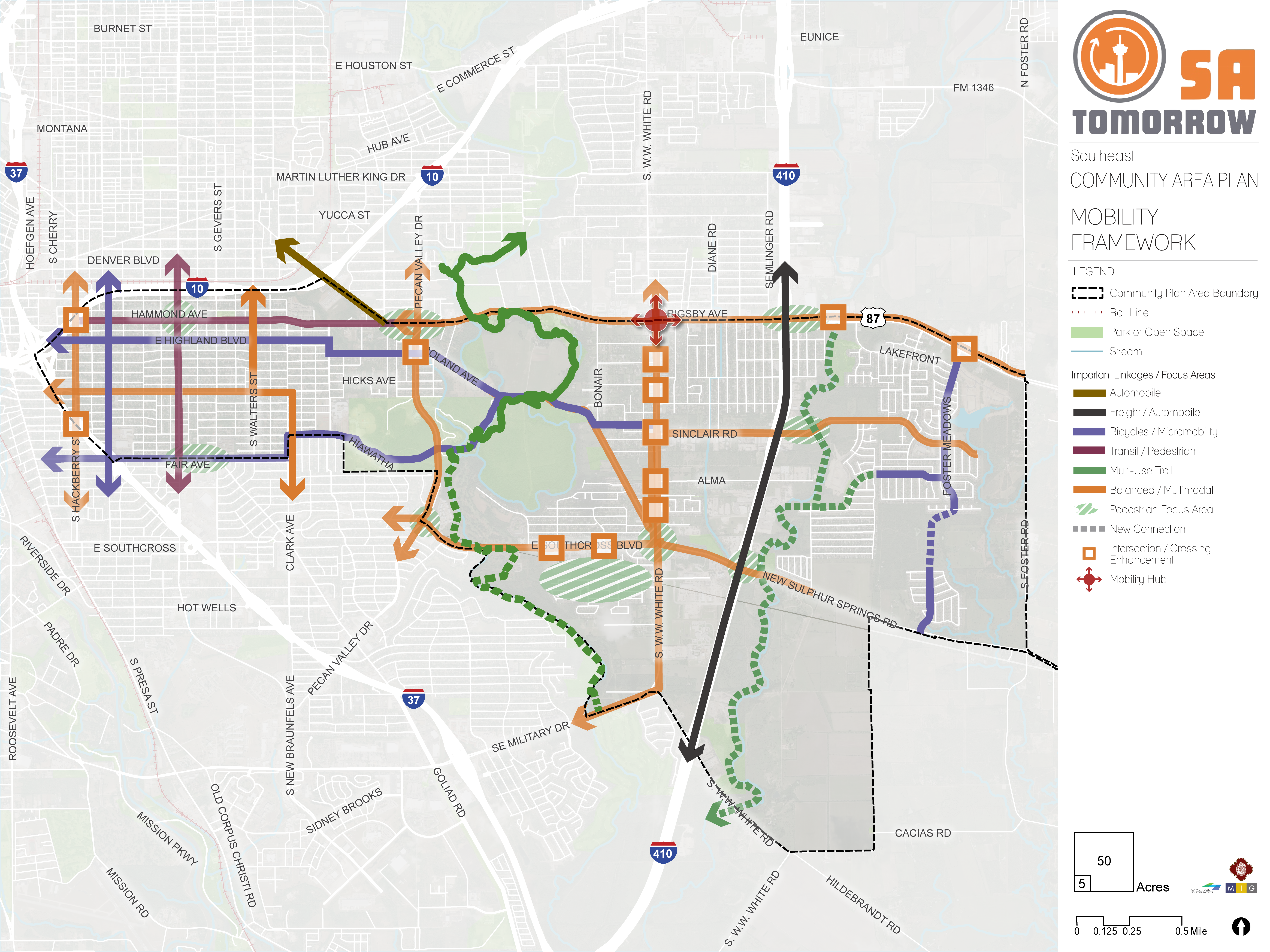
The map below highlights the Mobility Framework identified for the Southeast Community Area. Scroll down to learn more about the vision for Mobility in the Plan Area.
To provide specific feedback on the map, please click and drag a box on that location of the map and fill out the comment box. We would love to hear more from you!
You can also visit the bottom of the page to leave additional feedback.
Background and Vision
In 2016, the City of San Antonio adopted the SA Tomorrow Multimodal Transportation Plan, to make the City’s transportation system “sustainable, safe, convenient, efficient, and inclusive of all modes.” The plan adopted by City Council established “a shift in focus from moving vehicles to moving people,” to manage traffic congestion, and improve transportation choices. The plan identified two primary and interdependent methods for managing future traffic congestion:
- Develop a land use pattern and policy to promote local trips; and
- Encourage more transportation options, in addition to personal vehicles, to connect Regional Centers.
The SA Tomorrow Multimodal Transportation Plan acknowledged that we cannot build our way out of congestion by continuously adding additional lanes and that the Comprehensive Plan, and associated land use plans, are a primary opportunity to improve mobility in San Antonio. By welcoming more people to live, work, and play in urban centers, regional centers, and transit corridors, we can shorten trip lengths, offer more transportation choices, and improve quality of life.
The combined costs of housing and transportation (commonly referred to as H+T) are often a large portion of a household’s budget, with experts recommending the combined total not be more than 45% of household income. In the Greater San Antonio Region, that total on average is 53%. Walkable communities that provide great transit options can reduce the household transportation costs for the average person. If people have an alternative to driving alone, transportation costs can be stable even when gas prices rise. As some people choose to go to their destination on foot, bicycle, or public transit, the number of cars on the road will be minimized, and can potentially reduce traffic delays for people that choose to drive.
The Southeast Community Area is located south of Rigsby Avenue and extends east beyond Loop 410 on the east side of San Antonio’s city limits. The Plan Area has developed incrementally over 100 years through gradual waves of annexation. About one-third of development is residential land, ranging from neighborhoods that developed as early as the 1920s to new construction. The staggered growth in the plan area has created a diverse range of neighborhood and connectivity issues, with more conventional grid patterns of neighborhood blocks occurring to the west of the Plan Area, and longer blocks with irregular forms and cul-de-sacs occurring east of the Salado Creek Greenway.
Several major highways including I-37 and I-10 run adjacent to the Southeast Community Area and provide easy access to Downtown, Ft. Sam Houston Regional Center, Brooks Area Regional Center, and other regional employment areas. In addition to accessible highways, the Southeast Community Area is served by three VIA Metropolitan Transit bus routes as well as a frequent Skip Service (Route 552 known as the “Looper”), which provides a service that stops less frequently to offer riders a quick trip. When comparing the travel experience of people driving vehicles to the experience of people walking, taking public transit, and biking within the Plan Area, those choosing alternative modes of transportation encounter greater challenges including basic infrastructure gaps and uncomfortable or unsafe environments.
The Southeast Community Area Plan envisions neighbors and community partners collaborating to create a safe, attractive, and family-friendly community that strengthens social capital and provides a high quality, well-connected multimodal transportation network. Through land use policies and placemaking efforts, the area will become a local and regional destination that provides a high quality of life by balancing walkability, mobility, open spaces, and a sense of neighborhood identity.
Mobility Concepts
The recommendations in this plan will help create a user-friendly multi-modal transportation network that provides access to amenities and that links Southeast Community Area residents and employees to the greater San Antonio Area. The general concepts below serve as guiding principles for the more detailed Mobility Recommendations listed above, and several are illustrated for the Southeast Community Area on the Mobility ramework Map.
Recommendation #1
Continue implementing the San Antonio Vision Zero Action Plan.Recommendation #2
Complete the multimodal mobility network and establish new connections through partnerships.Connected multimodal networks are key components to providing mobility for all users, regardless of physical ability or financial status. Transit improvements ensure areas are accessible while bicycle and pedestrian infrastructure provide last-mile connections to and from transit facilities and key destinations. Urban design elements, such as driveway relocation, street calming, and complete streets, further support these improvements while providing safe and inviting spaces.
Balanced/Multimodal StreetsBalanced and multimodal street, or “complete streets” are envisioned for the Southeast Community Area, providing safe road designs for vehicles, pedestrians, and cyclists alike. The following streets are prioritized segments recommended for the Public Works Department to study for complete streets improvements: Hackberry Street from Rigsby Avenue to Steves Avenue; WW White Road from Rigsby Avenue to Chandler Road; Southcross Boulevard from Pecan Valley Drive to WW White Road; Rigsby Avenue from Clark Avenue to Salado Creek Greenway; Roland Road from WW White Road to Salado Creek Greenway; Pecan Valley Drive from Hiawatha Street to Southcross Boulevard; and Fair Avenue from New Braunfels Avenue to Walters Street.
Priority Multi-Use TrailsKey Salado Creek Greenway trail connections through the heart of the Southeast Community Area provide critical continuous arteries of separated pedestrian and bicycling infrastructure network, connecting numerous parks, retail locations, schools, and libraries. The critical access points to these community amenities provide opportunities to improve connections for people walking or bicycling with deliberate side paths or on-road infrastructure like crosswalks, sidewalks and bicycle facilities. New connections and trails are envisioned along: Along Rosillo Creek from Rigsby Avenue to New Sulphur Springs Road; and Neighborhood trail extension and connection along Salado Creek Greenway at Southcross Boulevard; and A more defined trailhead at Salado Creek Greenway and Roland Road.
Preferred Bicycle RoutesIn many parts of the Southeast Community Area, bicyclists currently ride in mixed-traffic on high-speed and high-volume roads. Additional bike infrastructure, such as designated, protected lanes, is highly recommended where feasible as part of complete streets and other improvement projects. These measures will improve riding conditions for today’s commuters and welcome newer, less confident bicyclists that are unaccustomed to riding alongside vehicles. The provision of bicycle parking and micro-mobility at transit stops provides an important connection for people wanting to access transit by bicycle and helps to address the ‘last mile’ challenge. Overall, this helps connect people to and from their destinations and transit.
Based on input from the Planning Team and other community stakeholders, the plan identifies priority bicycle routes for the Southeast Community Area including: East Highland Boulevard from I-10 to Elgin Avenue; Elgin Avenue from Highland Boulevard to Chickering Avenue; Chickering Avenue from Elgin Avenue to Roland Avenue; Roland Avenue from Talisman Road to Sinclair Road; Sinclair Road from Roland Avenue to WW White Road; Fair Avenue from I-37 to Clark Avenue; Clark Avenue from Fair Avenue to Hiawatha Road; Hiawatha Road from Clark Avenue to Salado Creek Greenway; Pine Street from I-10 to I-37; Foster Meadows Road from Rigsby Avenue to Channel View; Jasper Hollow from New Sulphur Springs Road to Hematite Rim; Lake Victoria Street from Lake Tahoe Street to Foster Meadows; and New connections between Foster Meadows Road and Jasper Hollow.
Corridors identified for balanced and multimodal complete streets along Hackberry Street, Steves Avenue, Clark Avenue, Walters Street, Pecan Valley Drive, Southcross Boulevard, New Sulphur Springs Road, WW White Road, SE Military Drive, and Sinclair Road would also incorporate cycling infrastructure as a component of the design based on future facility and feasibility studies by the Public Works Department.

Recommendation #3
Manage transportation demand by creating walkable places and supporting efficient transit operations through targeted interventions.Shifting users from driving alone to alternative modes of transportation can alleviate congestion along a corridor or within an area. This becomes more viable when alternatives are convenient, such as through pedestrian-friendly infrastructure and improved access to transit. To support growth and continue the vibrancy of the Plan Area’s employment areas and commercial nodes, the community needs places with easy, reliable, and congestion proof choices for traveling to and from work, school, and key destinations. While congestion can be viewed as a sign of economic health, delays caused by congestion waste valuable time and create transportation emissions that reduce air quality. The transportation industry has learned we cannot build our way out of congestion by continuously adding additional lanes, however, a series of targeted operational and multimodal interventions can provide more travel options and reduce the demand on our roadways. Targeted investments to reduce congestion and conflict zones that delays transit can help transit move more rapidly on San Antonio’s roadways and stay on schedule. These improvements, paired with other VIA Metropolitan Transit investments in service, can help make transit a more attractive travel option. These strategies can support the vibrancy of the Plan Area’s employment areas and commercial nodes, by connecting residents with easy, reliable, and congestion-proof choices to and from work, school, and key destinations. Key improvements that could improve transit mobility include peak-hour bus-only lanes that give priority to buses in times of peak traffic; queuing jump traffic signals to allow buses a chance to get ahead of the traffic; transit priority lanes; and bus bulbs to allow buses to pick up passengers without entering/exiting traffic. Studies will need to be conducted to determine the appropriateness for each strategy for areas of local congestion, including Rigsby Avenue, WW White Road, and Loop 410.

Recommendation #4
Support VIA Metropolitan Transit Rapid Transit Corridor service by prioritizing transit supportive policies and infrastructure near transit stations.Every person that rides transit is also a pedestrian. As VIA Metropolitan Transit improves transit options in Template and throughout San Antonio, these services should be easily accessed by people walking and bicycling to transit stations and stops. Investing in complete streets along transit corridors as well as streets that lead to stations will not only improve the transit riders’ experience, but also improve the experience of walking and riding a bicycle for everyone.
This recommendation supports the community's goal to Promote Great Transit, shared by the City and VIA Metropolitan Transit’s objectives to improve access to key destinations, decrease vehicle miles traveled, and increase walkability. More information on the City’s approach to implementing transit supportive policies and infrastructure near transit stations is available in the SA Corridors Framework Plan.
There are currently over twenty VIA Metropolitan Transit service routes that serve Template residents and employees, and others riding through the area. Future VIA Metropolitan Transit Rapid Transit Corridors or Primo routes are being evaluated by VIA related to the following roadways:
- Colorado/Fredericksburg Road
- San Pedro Avenue
- Broadway Street
- Cypress/ Euclid / Grayson Street

Southeast Community Area’s Mobility Needs
Investments in transportation improvements are continuously made to move large volumes of freight efficiently, link neighborhood development to growing employment opportunities, and provide adequate transit routes that connect to important destinations across the City. In addition, growing populations demand that streets not only carry people, goods, and services, but also serve as public spaces. Key mobility needs identified in this plan area include the following:
To address the transportation needs in the Southeast Community Area, a set of high-level recommendations have been developed to guide future decision making. Recommendations include modal and intersection priorities, shown in the Mobility Framework map Street Type recommendations as shown in the Street Types and Streets for People and Places maps. These mobility recommendations will be further refined in a coordinated manner with the City’s Public Works Department and other relevant partners such as Texas Department of Transportation (TxDOT), VIA Metropolitan Transit (VIA), and the Alamo Area Metropolitan Planning Organization (AAMPO).
Southeast Community Area Mobility Framework
The Mobility Framework lays out the vision for accommodating the constantly expanding mobility needs of the Southeast Community Area. Below are the principles to ensure a mobility network that is safe and inviting for people walking, shopping, parking, and driving in the Southeast Community Area.
Multimodal Priority Corridors
Streets play a multifaceted role in the Plan Area, serving as arteries for traffic, as links to amenities and recreation, and as public spaces. Changes to street design can help achieve the community’s vision of the Plan Area and better reflect the balance and prioritization of how motorists, bicyclists, transit users, and pedestrians will interact with each corridor. Modal emphasis corridors guide design treatments of a particular mode of mobility. A multimodal priority corridor does not exclude other users but helps guide tradeoffs and decisions during the design of a specific street.
AutomobileAutomobile corridors are envisioned to support high levels of motor vehicle travel daily. These corridors are often interstates, highways, arterials, and primary roads which provide connections to major destinations and link the Plan Area to other regions. Roland Avenue has been identified as a priority automobile corridor to facilitate travel to and from Rigsby Avenue and Southcross Boulevard. Automobile corridor improvements can relieve traffic congestion and enhance roadway design to increase the safety of motor vehicle travel.
FreightFreight corridors are envisioned to support high levels of goods movement, often by freight trucks that travel from industrial or commercial areas to major destinations. The Planning Team has identified Loop 410 as a priority corridor to enhance goods movement and relieve congestion along the interstate and through the Plan Area, specifically at the on and off ramps at Sinclair Road, Rigsby Avenue, and Southcross Boulevard, which all support larger truck traffic volumes.
BicyclesBicycle corridors are envisioned to provide biking as a convenient, safe, and comfortable mobility option for all ages and abilities. An integrated network of bicycle routes along with well-designed streets in key activity areas aim to fill the gaps in the multimodal system. East Highland Boulevard, Fair Avenue, and the north side of Foster Meadows were identified as priority corridors to enhance the existing bicycle network.
Transit/PedestrianTransit and pedestrian corridors are envisioned to provide the community with easy, reliable, and congestion-proof choices for traveling to and from work, school, and other key destinations. Streets, intersections, and traffic signals greatly influence transit service reliability and the transit passenger experience. Providing streets that enable reliable and frequent transit service and a walkable environment allows users to choose travel options besides driving, alleviating a primary cause of congestion. Dedicated transit lanes, signal timing, and operational improvements can keep transit vehicles moving regardless of automobile traffic. Priority transit corridors in the Southeast Community Area are currently along Rigsby Avenue (west of Roland Avenue) and South New Braunfels Avenue which connects the Brooks area to Fort Sam Houston and Downtown with VIA Metropolitan Transit’s Primo service. This area already includes many bus stops but existing facilities could be improved to enhance safety and attract more transit riders. All transit passengers are also pedestrians first, so enhancements to sidewalks, crosswalks, and streetscapes amenities that increase the safety and comfort of walking are critical in these corridors.
Multi-Use TrailMulti-use trail corridors are envisioned to provide continuous arteries of separated pedestrian and bicycle facilities that connect numerous destinations, parks, retail and commercial development, schools, libraries, and residential areas. A multi-use trail provides access points to regional amenities and improves connections for people walking or biking. The Southeast Community Area is already home to the Salado Creek Greenway, a growing network of multi-use trails. There is an opportunity to enhance the trail with additional connections extending south past East Southcross Boulevard. The extension of the greenway trail will provide an easy pathway for people walking or cycling to numerous attractions and open spaces.
Rosillo Creek has been identified as a potential new trail in the Southeast Community Area. This creek is located just east of Loop 410 and runs adjacent to the highway. Similar to the Salado Creek Greenway and other City creek trail systems, such as the Westside Creeks Trails, this trail would create safe, non-vehicular connections to neighborhoods and commercial destinations. Potential trailheads could occur at Rigsby Avenue, Tealer Park, Sinclair Road, and New Sulphur Springs Road.
Balanced/MultimodalBalanced and multimodal corridors are envisioned as “complete streets” that consider all users and accommodate all ages and abilities including children, older adults, and persons with disabilities. These corridors balance the priorities of multiple modes and require community conversations and case-by-case design to best align with the community vision. The function of the road, level of traffic by mode, and adjacent land use and intensity will help determine the road type and design features. The Southeast Community Area has multiple priority locations for multimodal investments. South WW White Road was identified as having the highest potential as it bisects the Plan Area and provides access to a range of mixed use development, low-density residential development, parks and open spaces. Similar to South WW White Road, Rigsby Avenue east of Roland Avenue has been identified another corridor that should incorporate a balance of various modes of mobility. Other corridors identified by the community for evaluation of multimodal street designs include Sinclair Road, Pecan Valley Road, Southcross Boulevard, South Hackberry, and Steves Avenue. Multimodal investments will enhance connectivity while simultaneously supporting the community goal of promoting well-being and safety.
Pedestrian Focus AreasPedestrian focus areas refer to specific nodes that accommodate significant volumes of pedestrian activity. These focus areas aim to create high-quality street-level experiences to enhance the economic strength of commercial and mixed-use districts. These areas include large sidewalks, safe and balanced intersections, ample crossing opportunities, and design characteristics focused on keeping pedestrians safe while providing a comfortable overall experience. Pedestrian focus areas have been identified near the intersection of East Southcross Boulevard and South WW White Road, Southside Lions Park, Rigsby Avenue, and Fair Avenue. These areas have been identified near major neighborhood origins and destinations to enhance pedestrian access, mobility, and safety.
Intersection / Crossing EnhancementsIntersection and crossing enhancements are envisioned as intuitive and predictable crossings for all users. Enhancement locations are identified where crossing is considered a priority and pedestrians, motorists, and bicyclists share space. Whether signalized or un-signalized, crossings where a high level of multimodal activity, including pedestrian, bicycle, and motor vehicle crossings, will facilitate predictability for all uses. Intersection enhancements could include lowering motor vehicle travel speeds when appropriate and ensuring high pedestrian visibility. Priority intersection and crossing enhancement locations are identified where complex movements occur and potential conflicts between pedestrians, bicyclists, and drivers exist. The Southeast Community Area has identified a total of 12 priority intersections, including five located on WW White Road, as it provides connections to multiple residential and commercial areas.
Mobility HubsMobility hubs are envisioned as scalable nodes of mobility options, like frequent transit, shared rides, bicycling, and micro-mobility. These areas converge multimodal access and connectivity with adequate lighting, shelters, benches, real-time information, accessible sidewalks and pedestrian crossings. A mobility hub is identified at the intersection of Rigsby Avenue and WW White Road.
Southeast Community Area Street Types
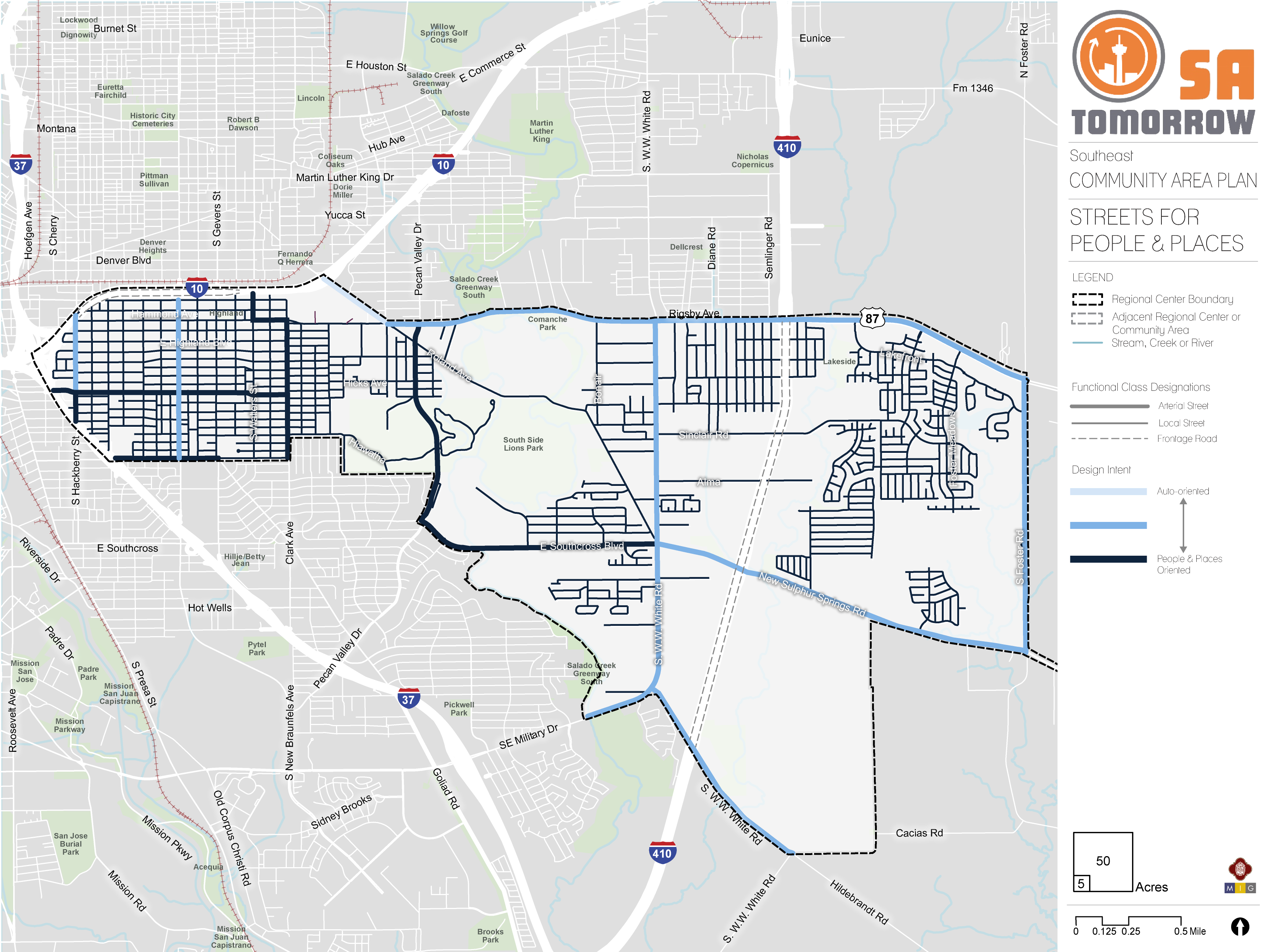
Southeast Community Area Streets for People and Places
As communities evolve and grow, so do the demands on the mobility system. The location and type of growth in an area or along a corridor help determine the demand on the transportation network and the viability of various transportation options. This interdependence makes it crucial to plan for transportation and land use collectively. Streets are organized not only by role and function, but also by the character and surrounding context.
Land uses encouraging mixed-uses and higher density developments on major roadways will lead to additional pedestrians, bicyclists, transit riders, cars, and freight delivery trucks of various sizes. Future land use also influences other factors, such as drop-off delivery zones, shared mobility hubs, and walkability. The map below shows the interactions between future land use and transportation plans. The street type classifications integrate transportation and land use to guide context-sensitive mobility solutions.
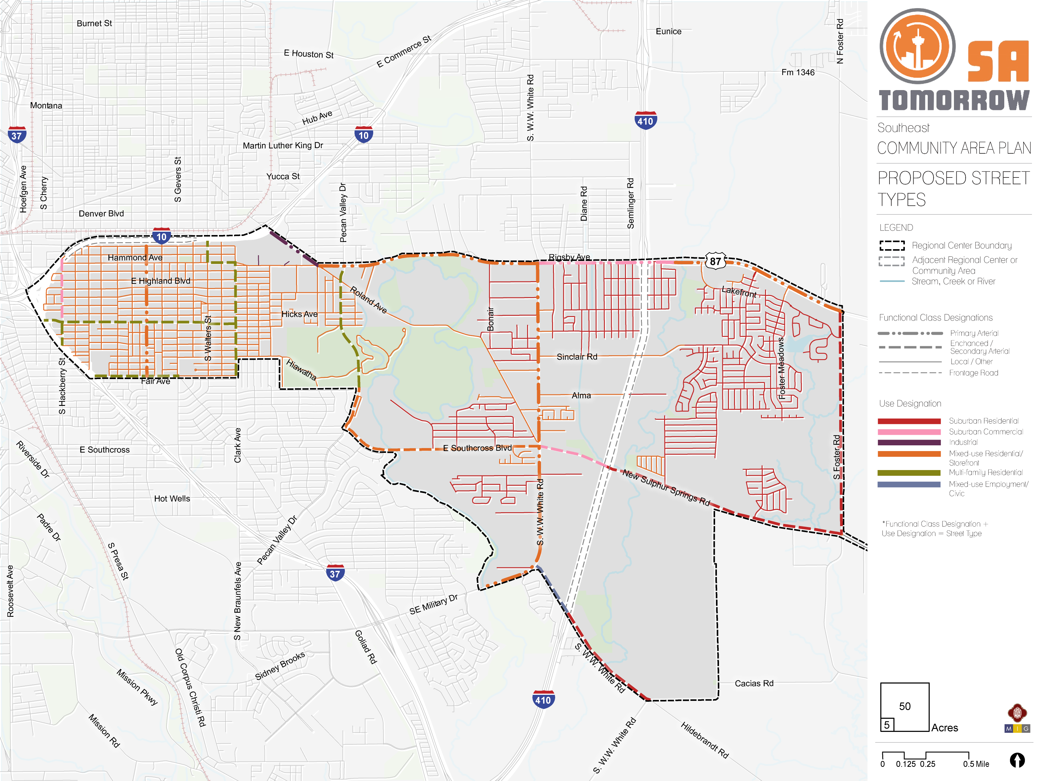
Southeast Community Area Proposed Street Types
Relationship between the Street and Buildings
Safe and vibrant streetscapes depend on how buildings integrate with surrounding sidewalks. Minimizing building setbacks, the distance between a building facade and the street, is key for creating a walkable and more connected public realm. Buildings that meet the sidewalk directly connect pedestrians to destinations and create an enlivened urban space with opportunities to activate ground-floor uses and provide shopping and entertainment offerings with convenient access.
Smaller building setbacks are characteristic of Mixed-Use Local, or Urban/Suburban Local street typologies, which prioritize pedestrian-oriented design. Meanwhile, larger setbacks that can accommodate front-end parking, are more characteristic of secondary arterials (whether suburban, industrial, mixed-use, or urban). Primary arterials are designed to move vehicles and may require large setback minimums to accommodate additional parking.
The Streets for People and Places below illustrates the Plan Area’s streets classified into the same gradient of intensity between car-focused and people/places-focused. As shown on the map, many of the major roadways in the Southeast Community Area should have an equal emphasis on people-and places and auto-oriented design approach going forward to support the future land use vision of more mixed-uses along those corridors. Other major thoroughfares such Southcross Boulevard, Steves Avenue, and Pecan Valley Drive, which are already primarily auto-oriented, should have more emphasis on street design oriented towards people, their safety, and how they interact with the places along those corridors.
Vehicle SpeedsA successful street hierarchy will align travel speeds with street usages and will decrease speeds accordingly by roadway function. While major regional roads may require higher speeds to accommodate heavy traffic flows, most smaller roadways serve lower volumes of vehicles, thus having lower speeds. On these roads, lower speeds ensure a safe environment for vehicles and people alike.
Street typologies that focus on moving vehicles, such as Suburban Commercial, Residential, or Industrial Super and Primary Arterials, will feature higher speeds. However, typologies that focus on people and places, such as Mixed-Use, Multi-family, Urban/Suburban Local Roads and Secondary Arterials, will feature lower speed limits, to increase road safety for both people and vehicles.
ParkingParking provides access to work, retail, or entertainment. Cars searching for on-street parking create serious traffic and safety challenges. Incorporating safe street design elements, such as buffering between bike lanes and traffic, can create a safer on-street parking environment.
Street types that emphasize people and places, such as those with featuring Mixed Use or Multi-family developments will restrict the supply of parking overall. Restricting space allocated for parking allows for more active uses, denser physical environments, and more connectivity for pedestrians and cyclists. Meanwhile, intermediary street typologies that support vehicles as well as people and places will likely offer some on-street parking, in addition to smaller on-site lots. Conversely, Suburban Contexts or Super and Primary Arterials may forgo on-street parking altogether, favoring large surface lots and structures.
Curb AccessSpace between the curb and the travel lanes provides an opportunity to serve many uses such as driveways, bus lanes, cycle tracks, on-street parking, bicycle parking, freight drop-off delivery zones, or shared mobility hubs. This flexible zone can be converted based on demand and play a role in street activation. The design of the curb influences how cars and people enter and exit work, residential, and retail environments. Addressing areas where traffic and turning patterns increase the risk of crashes will reduce conflicts between driveway traffic and pedestrians and will improve roadway safety.
Suburban Commercial and Super or Primary Arterials typologies will focus on the ease of ingress and egress for vehicles, while Mixed-Use or Local street typologies focused on moving people will emphasize how vehicle access can coexist with safe, walkable environments.
Lane WidthLane width determines how cities can allocate space for motorists, buses, trucks, bikes, and parked cars. Streets often dedicate space for bike lanes, parking, safety islands, and travel lanes. The lane width will vary based on the surrounding context and modal priority as transit, freight, and emergency response vehicles require wider travel lanes.
Wider lane widths are designed to move vehicles in high-speed environments. For example, a Suburban Primary Arterial will be wide enough to efficiently move passengers through residential and commercial environments, while Mixed-Use Local or Suburban Local environments have narrow lanes to reduce crossing distances for pedestrians and to help promote slower driving speeds.
